How Satellite Remote Sensing Is Shaping the Future of Agriculture: A Comprehensive Industry Analysis
- Satellite Remote Sensing in Agriculture: Market Landscape and Key Drivers
- Emerging Technologies and Innovations in Agricultural Remote Sensing
- Key Players and Competitive Dynamics in Satellite-Enabled Farming
- Market Growth Projections and Investment Opportunities
- Regional Trends and Adoption Patterns in Satellite Agriculture
- The Road Ahead: Evolving Roles of Satellites in Smart Farming
- Barriers, Risks, and Untapped Potential in Satellite-Based Agriculture
- Sources & References
“As agriculture faces mounting challenges from climate change and rising food demand, Earth observation technologies – using satellite imagery and remote sensing – are transforming how we grow food innovationnewsnetwork.com.” (source)
Satellite Remote Sensing in Agriculture: Market Landscape and Key Drivers
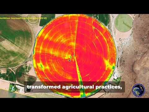
Satellite remote sensing is fundamentally transforming modern agriculture by providing farmers, agronomists, and policymakers with unprecedented access to real-time, high-resolution data. This technology leverages satellites equipped with advanced sensors to monitor crop health, soil conditions, water usage, and more, enabling data-driven decisions that boost productivity and sustainability.
Precision Agriculture and Yield Optimization
- Satellites deliver multispectral and hyperspectral imagery, allowing for precise monitoring of crop growth stages, early detection of diseases, and assessment of nutrient deficiencies. This supports targeted interventions, reducing input costs and maximizing yields (NASA).
- According to a 2023 report, the global precision farming market—heavily reliant on satellite data—is projected to reach $16.35 billion by 2028, growing at a CAGR of 12.6% (MarketsandMarkets).
Resource Management and Sustainability
- Remote sensing enables efficient water management by tracking soil moisture and evapotranspiration, crucial for drought-prone regions. For example, the European Space Agency’s Sentinel satellites provide open-access data that help optimize irrigation schedules (ESA).
- Satellite data also supports sustainable land use by monitoring deforestation, crop rotation, and soil erosion, aligning with global efforts to reduce agriculture’s environmental footprint (NASA Earth Observatory).
Market Landscape and Adoption
- The satellite remote sensing in agriculture market is rapidly expanding, with North America and Europe leading adoption due to advanced infrastructure and supportive policies. Asia-Pacific is emerging as a high-growth region, driven by large-scale farming and government initiatives (GlobeNewswire).
- Key players include Planet Labs, Airbus, and Maxar Technologies, offering increasingly affordable and accessible satellite imagery services tailored for agriculture (Planet Labs).
In summary, satellite remote sensing is revolutionizing agriculture by enabling precision farming, improving resource management, and supporting sustainability. As technology advances and costs decrease, its adoption is set to accelerate, reshaping the future of global food production.
Emerging Technologies and Innovations in Agricultural Remote Sensing
Satellites are fundamentally transforming modern agriculture by providing farmers with unprecedented access to real-time, large-scale data about their fields. Remote sensing technology, which involves collecting information from a distance using satellite or aerial imagery, is enabling precision agriculture practices that optimize yields, reduce costs, and minimize environmental impact.
One of the most significant advancements is the use of multispectral and hyperspectral imaging. These technologies allow satellites to capture data beyond the visible spectrum, revealing critical information about crop health, soil moisture, and nutrient deficiencies. For example, the European Space Agency’s Sentinel-2 satellites provide high-resolution optical imagery that is widely used for monitoring crop growth and detecting stress factors such as drought or disease.
According to a 2023 report by MarketsandMarkets, the global market for agricultural remote sensing is projected to reach $2.2 billion by 2027, growing at a CAGR of 12.2%. This growth is driven by the increasing adoption of satellite-based solutions for yield prediction, irrigation management, and pest detection.
- Yield Prediction: By analyzing satellite imagery, farmers can estimate crop yields with greater accuracy. Companies like Planet Labs offer daily satellite images that help track crop development and forecast harvests.
- Irrigation Management: Satellites equipped with thermal sensors can detect variations in soil moisture, enabling targeted irrigation and water conservation. The NASA SMAP mission, for instance, provides global soil moisture data that supports efficient water use.
- Pest and Disease Detection: Early identification of pest infestations or disease outbreaks is possible through changes in plant reflectance captured by satellites, allowing for timely intervention and reduced crop loss.
Furthermore, the integration of satellite data with artificial intelligence and machine learning is enhancing the accuracy and usability of remote sensing in agriculture. Platforms like Climate FieldView and Crofarm are leveraging these technologies to deliver actionable insights directly to farmers’ smartphones.
In summary, satellites are revolutionizing farming by making remote sensing data more accessible, actionable, and affordable, paving the way for a new era of data-driven agriculture.
Key Players and Competitive Dynamics in Satellite-Enabled Farming
Satellites are fundamentally transforming agriculture by enabling remote sensing technologies that deliver real-time, high-resolution data to farmers and agribusinesses. This revolution is driven by a dynamic ecosystem of key players, ranging from established aerospace giants to innovative agri-tech startups, all competing to provide actionable insights that optimize crop yields, resource use, and sustainability.
Key Players in Satellite-Enabled Farming
- Planet Labs: Operating the world’s largest fleet of Earth-observing satellites, Planet Labs provides daily, high-resolution imagery that supports precision agriculture, crop monitoring, and land management. Their data is used by major agribusinesses and governments worldwide (Planet Labs Agriculture).
- Trimble: A leader in agricultural technology, Trimble integrates satellite imagery with GPS and IoT solutions to deliver field mapping, yield monitoring, and variable rate application services (Trimble Agriculture).
- John Deere: Through its Precision Ag Technology suite, John Deere leverages satellite data for automated guidance, remote diagnostics, and real-time field analytics, enhancing operational efficiency for farmers.
- Airbus Defence and Space: Airbus offers high-resolution satellite imagery and analytics for crop health monitoring, yield prediction, and risk assessment, serving both commercial and governmental clients (Airbus Agriculture).
- Climate FieldView (Bayer): This digital platform combines satellite imagery with on-farm data to provide insights on crop performance, disease risk, and input optimization (Climate FieldView).
Competitive Dynamics
The competitive landscape is marked by rapid innovation and strategic partnerships. Companies are racing to improve the spatial and temporal resolution of satellite data, integrate AI-driven analytics, and offer user-friendly platforms. According to MarketsandMarkets, the global satellite-enabled smart agriculture market is projected to reach $7.1 billion by 2028, growing at a CAGR of 13.8% from 2023. Startups like Crofarm and Geosys are also gaining traction by offering specialized analytics and localized solutions.
As satellite technology becomes more affordable and accessible, competition is intensifying, driving down costs and expanding the reach of precision agriculture. The result is a rapidly evolving market where data-driven farming is becoming the new norm, promising increased productivity and sustainability for the global food system.
Market Growth Projections and Investment Opportunities
Satellites are fundamentally transforming the agricultural sector through advanced remote sensing technologies, enabling farmers to optimize yields, reduce costs, and make data-driven decisions. The global market for remote sensing in agriculture is experiencing robust growth, driven by the increasing adoption of precision farming, climate change adaptation, and the need for sustainable food production.
According to a recent report by MarketsandMarkets, the remote sensing services market is projected to grow from $13.0 billion in 2023 to $25.5 billion by 2028, at a compound annual growth rate (CAGR) of 14.2%. Agriculture is one of the fastest-growing application segments, fueled by the demand for real-time crop monitoring, soil health assessment, and resource management.
- Yield Optimization: Satellite imagery enables farmers to monitor crop health, detect diseases early, and apply fertilizers or pesticides precisely where needed. This targeted approach can increase yields by up to 20% while reducing input costs (McKinsey).
- Water Management: Remote sensing helps in tracking soil moisture and irrigation needs, crucial for water-scarce regions. This technology can reduce water usage by 30% or more, supporting sustainable agriculture (NASA).
- Climate Resilience: Satellites provide early warnings for extreme weather events, enabling farmers to take preventive measures and minimize losses. This is increasingly important as climate volatility impacts global food security (FAO).
Investment opportunities abound across the value chain. Startups and established companies are developing AI-powered analytics platforms that interpret satellite data for actionable insights. Venture capital investment in agtech, including remote sensing, reached $10.5 billion globally in 2022 (AgFunder). Governments and international organizations are also funding initiatives to expand satellite coverage and data accessibility for smallholder farmers.
In summary, the integration of satellite remote sensing in agriculture is not only driving market growth but also opening new avenues for investment, innovation, and sustainable food production worldwide.
Regional Trends and Adoption Patterns in Satellite Agriculture
Satellites are fundamentally transforming agriculture by enabling remote sensing technologies that provide farmers with unprecedented insights into their fields. This revolution is being adopted at varying rates across different regions, shaped by local infrastructure, investment, and policy support.
North America leads in satellite agriculture adoption, driven by large-scale commercial farms and robust agri-tech investment. The United States, in particular, has seen widespread integration of satellite imagery for crop monitoring, yield prediction, and precision farming. According to the USDA, over $300 million has been allocated to expand satellite-based monitoring and data-driven decision-making in 2023. Canadian farmers are also leveraging satellite data for soil health and irrigation management, supported by government initiatives like the Canadian Space Agency’s investments in agri-satellite technology.
Europe is rapidly catching up, propelled by the European Union’s Copernicus Programme, which provides free access to high-resolution satellite data. Countries like France, Germany, and the Netherlands are at the forefront, using remote sensing for compliance with environmental regulations and sustainable farming practices. The EU’s Common Agricultural Policy (CAP) now encourages satellite-based monitoring to verify subsidy compliance and promote eco-friendly agriculture.
Asia-Pacific shows diverse adoption patterns. In Australia, satellite-driven platforms like CSIRO’s Earth Observation are widely used for drought management and crop forecasting. In India and China, government-backed programs are expanding access to satellite data for millions of smallholder farmers, aiming to boost productivity and climate resilience (ISRO, China Daily).
Latin America and Africa are emerging markets for satellite agriculture. Brazil and Argentina are investing in remote sensing for large-scale soybean and corn production (Embrapa). In Africa, initiatives like Digital Earth Africa are democratizing access to satellite data, supporting smallholder farmers with early warning systems and land use monitoring.
Overall, satellite remote sensing is revolutionizing farming worldwide, with regional adoption patterns reflecting local priorities, resources, and policy frameworks. As satellite data becomes more accessible and affordable, its impact on global agriculture is set to deepen further.
The Road Ahead: Evolving Roles of Satellites in Smart Farming
Satellites are rapidly transforming the agricultural landscape, ushering in a new era of precision and efficiency through advanced remote sensing technologies. By providing real-time, high-resolution data from space, satellites empower farmers to make informed decisions, optimize resource use, and boost crop yields while minimizing environmental impact.
Remote sensing involves capturing images and data about the Earth’s surface using sensors mounted on satellites. These sensors can detect a range of electromagnetic wavelengths, including visible, infrared, and microwave, enabling the monitoring of various crop and soil parameters. According to the Food and Agriculture Organization (FAO), satellite-based remote sensing is now a cornerstone of modern smart farming, supporting everything from crop health assessment to irrigation management.
- Crop Monitoring and Health Assessment: Satellites provide frequent, large-scale imagery that helps detect crop stress, disease outbreaks, and pest infestations early. For example, the European Space Agency’s Sentinel-2 satellites deliver multispectral data every five days, allowing for near real-time monitoring (ESA Sentinel-2).
- Soil and Moisture Analysis: Microwave sensors on satellites like NASA’s SMAP (Soil Moisture Active Passive) mission measure soil moisture levels globally, aiding in drought prediction and irrigation planning (NASA SMAP).
- Yield Prediction and Forecasting: By analyzing vegetation indices such as NDVI (Normalized Difference Vegetation Index), satellites help estimate crop yields with increasing accuracy. This data is crucial for supply chain planning and food security assessments (MDPI Remote Sensing).
- Resource Optimization: Satellite data enables variable rate application of fertilizers, pesticides, and water, reducing waste and environmental impact. According to McKinsey, precision agriculture powered by satellites can increase yields by up to 30% while cutting input costs.
As satellite technology advances, with higher resolution sensors and more frequent data collection, its role in agriculture will only expand. The integration of satellite data with AI and IoT devices promises even greater insights, paving the way for fully autonomous, data-driven farms. The road ahead is clear: satellites are not just supporting agriculture—they are revolutionizing it.
Barriers, Risks, and Untapped Potential in Satellite-Based Agriculture
Satellites are fundamentally transforming agriculture by providing farmers and agribusinesses with unprecedented access to real-time, high-resolution data. Remote sensing technologies—using satellites equipped with multispectral and hyperspectral sensors—enable the monitoring of crop health, soil moisture, pest infestations, and even nutrient deficiencies across vast tracts of land. This data-driven approach, often referred to as “precision agriculture,” allows for targeted interventions, reducing input costs and environmental impact while boosting yields.
According to the Global Precision Farming Market Report 2023-2028, the global precision farming market is projected to reach $16.35 billion by 2028, with satellite-based remote sensing playing a pivotal role in this growth. Companies like Planet Labs and Satellogic are deploying constellations of small satellites, delivering daily imagery at resolutions as fine as 3-5 meters, which is detailed enough to detect subtle changes in crop vigor and field conditions.
Despite these advances, several barriers and risks remain. High-resolution satellite imagery can be expensive, limiting access for smallholder farmers, especially in developing regions. Data processing and interpretation require technical expertise and robust digital infrastructure, which are not universally available. Additionally, cloud cover can obscure optical satellite imagery, reducing data reliability during critical growing periods (MDPI Remote Sensing).
Data privacy and security are also emerging concerns, as the aggregation of farm-level data could expose sensitive information to competitors or unauthorized third parties. Regulatory frameworks for data ownership and sharing are still evolving, creating uncertainty for stakeholders (OECD).
Nevertheless, the untapped potential is significant. Advances in artificial intelligence and machine learning are making it easier to extract actionable insights from satellite data. The integration of satellite imagery with other data sources—such as drones, IoT sensors, and weather models—promises even greater accuracy and utility. As costs decline and accessibility improves, satellite-based remote sensing is poised to become a cornerstone of sustainable, climate-smart agriculture worldwide.
Sources & References
- How Satellites Are Revolutionizing Farming: The Full Scoop on Remote Sensing in Agriculture
- NASA
- MarketsandMarkets
- ESA Sentinel-2
- NASA Earth Observatory
- Global Precision Farming Market Report 2023-2028
- Planet Labs
- Crofarm
- Trimble Agriculture
- Precision Ag Technology
- Airbus Agriculture
- McKinsey
- Food and Agriculture Organization (FAO)
- AgFunder
- Canadian Space Agency’s investments
- Copernicus Programme
- Common Agricultural Policy (CAP)
- CSIRO’s Earth Observation
- ISRO
- China Daily
- Embrapa
- Digital Earth Africa
- Satellogic